Indian Monsoon
Indian monsoon is one of the most prominent weather systems in the world.
The Indian monsoon is one of the most complex weather systems in the world. It originates around Australia and goes all the way up to Tibet. Here is how the system works.
The entire monsoon activity in the world takes place between 30 degrees north and south latitudes. Sometime in January, a high pressure area called Mascarenas High builds up off the western coast of Australia. It then moves west. Travelling roughly 2,500 km, the monsoon reaches Somalia where the coast is high. This deflects winds back across Indian Ocean and Arabian Sea. This is called the Somalia jet.
With summer setting over the Indian subcontinent in April, land starts to heat up. As hot air over the land mass rises, a low pressure area gets formed, which draws air from the high-pressure area over the sea. The Somalia jet stream brings moisture-laden winds from high pressure area to India. These winds hit India from the south-west.
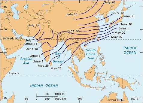
Winds that gather moisture over Arabian Sea lash the Western Ghats where some areas receive an average rainfall of 2,000 mm. Winds that gather moisture over Bay of Bengal hit north-eastern states by June 1. This brings rain to West Bengal and Bihar. Both the streams merge over central India to power the journey of the monsoon towards Delhi and Jammu.
However, by this time, the winds loose most of their moisture, hence north Indian states receive less rain than coastal areas. The last place that the south-west monsoon hits in India is west Rajasthan.